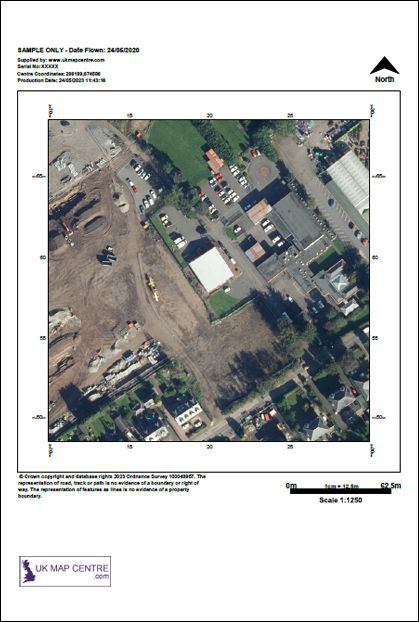
Ordnance Survey Aerial Imagery 1:1250 Scale Extracts - OrthoRectified (no building lean)
OS MasterMap Topography Layer® Imagery @ 1:1250
A 1:1250 scale aerial site plan provides high-resolution, ortho-rectified imagery precisely aligned to the OS MasterMap Topography Layer. These licensed Ordnance Survey aerial photos provide an accurate view of your chosen area in the UK. Ideal for surveying, planning, and visual asset monitoring, aerial photo maps offer reliable ground detail for professional use.
What Are OS Aerial Maps?
Ordnance Survey 1:1250 maps are licensed aerial photography extracts aligned to the OS MasterMap Topography Layer. Each file is colour-balanced, geometrically corrected, and supplied at high resolution for exceptional accuracy. The 1:1250 scale map is perfect for engineers, surveyors, and planners who require a dependable and true-to-scale visual reference.
Key Features
- Supplied as 1:1250 scale extracts
- Covers selected areas of England, Scotland, and Wales — both urban and rural
- Ideal for planning and environmental monitoring
- Easy postcode-based site selection
When Do I Need a 1:1250 OS Aerial Map?
A 1:1250 aerial survey map is essential when detailed visual verification of the ground is required. These maps are widely used in planning applications, offering clear, real-world views of boundaries, site access points, and the surrounding landscapes.
Typical Uses
- Architects and engineers preparing planning submissions requiring licensed aerial maps.
- Surveyors conducting land boundary analysis or visual checks of pipelines, trees, and road markings.
- Councils and developers assessing areas for transport or urban growth projects.
- Utility and energy companies needing aerial site plans to check access routes and monitor installations.