Ordnance Survey 1:25,000 Colour Explorer Scale Map Extracts
OS Explorer Maps at 1:25,000 scale are detailed digital extracts used by cyclists, walkers, horse riders and outdoor professionals across the UK. They provide the same trusted OS mapping you’ll find in the orange Explorer paper series, now available as quick digital downloads.
OS explorer maps show terrain with detail and clarity, and are widely used by farmers, land managers and emergency responders.
Order OS Explorer Maps today and receive licensed Ordnance Survey extracts by email in under 30 minutes.
WHAT IS A 1:25000 SCALE MAP?
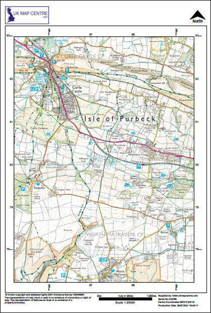
The OS Explorer Map is produced at a detailed 1:25,000 scale (4 cm = 1 km). It is the most detailed Ordnance Survey leisure map available for Great Britain. The 1:25000 map includes rich terrain detail such as footpaths, contour lines, vegetation, campsites, public rights of way, and field boundaries, making it ideal for walking, cycling, navigation, and outdoor recreation.
Key details and benefits:
- Identical detail as the Ordnance Survey Explorer Maps
- Clear mapping suitable for emergency responders
- Contours for accurate elevation awareness
- Vegetation and land cover clearly shown
- Landscape features such as scree slopes and shoreline detail
- Tourist attractions, shoreline detail and rights of way clearly marked
- Field boundaries and access land included
OS 1:25000 Extract
- Colour
- PDF, TIFF or JPG
- A4 to A0 size
- North Arrow
- Scale Bar
- Licence Number
WHEN DO I NEED AN OS EXPLORER MAP?
An OS Explorer Map is required when you need a clear view of an local area with precise detail. It is designed for navigation and outdoor activity, offering more local information than broader-scale products such as Landranger 1:50,000 Maps or technical datasets like OS MasterMap for CAD.
With UK Map Centre, you can quickly select the area covered and order OS Explorer Maps online in digital formats. These Explorer Ordnance Survey Maps are one of the most popular products for leisure and exploration, providing licensed mapping that’s trusted for both outdoor activities and reference reports.
Buy Ordnance Survey Maps and get the trusted 1:25000 scale detail shown in the orange series, now available as digital downloads.
- Same detail as the popular OS Explorer paper map series
- Suitable for emergency responders
- Contours
- Vegetation
- Scree
- Shoreline detail
- Shows field boundaries