


Ordnance Survey 1:10 000 Scale Vector Data - DXF | DWG
Available Formats via Email: GIS format: GML | GeoPackage and CAD format: Vector Colour DWG | Lines DXF
Ordnance Survey Premium Licenced Partner • Fully Licenced official OS mapping • Scalable and Layered OS Mid-scale Vector Data
OS VectorMap Local (VML 10k) - DWG Colour, DWG/DXF Lines & GIS Formats
OS VectorMap Local (VML 10k) is a mid-scale vector mapping product from Ordnance Survey at 1:10,000 scale. It provides detailed mapping suitable for larger rural or urban areas and regional-scale projects, balancing detail and usability - showing surface features, generalised building outlines, water features, street names and leisure areas without the heavy file sizes of OS MasterMap.
Every order delivers the latest data for your chosen site, extracted to the exact area you specify and delivered by email within 20 minutes as a single ZIP file.
Order OS VectorMap Local today for fast digital delivery in 20 minutes - fully licensed and compatible with GIS and CAD software.
Available Formats
DWG Colour
Full-colour layered DWG with solid area fills, styled road casings, OS symbols and stitched text. Rendered to the Ordnance Survey VectorMap Local specification using the official Mapbox GL FullColour stylesheet. Compatible with AutoCAD 2000+ and all major CAD software. Produced using Official Autodesk® Software.
DWG Lines & DXF Lines
Clean black-and-white linework - outlines only, no area fills. Ideal for base plans, overlay drawings and printing. Available as DWG for AutoCAD or open DXF for QGIS, Global Mapper, MicroStation and any software that reads DXF.
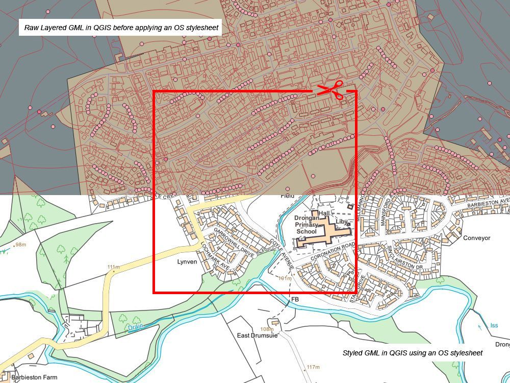
GeoPackage & GML for GIS
Raw OS VectorMap Local geometry and attributes in GeoPackage or GML format. Six clean layers ready for QGIS, ArcGIS Pro, FME and MapInfo. Apply the free OS Full Colour or Backdrop stylesheets for instant cartographic rendering.
OS Terrain 5 Contours (Optional)
Add 5-metre interval contour lines on separate dedicated layers. For CAD users, main contours and labelled index contours sit on independent layers for easy toggling. For GIS users, contours are delivered as a separate file in GeoPackage or GML.
When Do I Need OS VectorMap Local?
- Site context and location plans at 1:5,000 to 1:25,000
- Planning application drawings and environmental assessments
- Land-use planning over large rural or semi-rural areas
- Forestry and agricultural management with OS terrain data
- Flood risk assessment and drainage analysis
- Insurance mapping and estate management projects
- Landscape architecture and permaculture site layouts
- Regional transport and infrastructure planning
VectorMap Local is a generalised mid-scale mapping product with simplified road widths and building outlines - ideal for covering large areas efficiently, but not a replacement for the survey-accurate geometry in OS MasterMap. If your project requires precise individual building outlines, exact boundary lines, 3D building heights or large-scale site plans at 1:200 to 1:2,500, see our OS MasterMap DWG & DXF extracts.
Need to cover even larger areas? Our OS 1:10k GML Vector Tiles deliver complete tile-based coverage, or to save time on styling use our ready-styled 1:10k GeoTIFF Raster Tiles for instant cartographic output.
CAD Software Compatibility
- AutoCAD by Autodesk
- Revit
- Civil 3D
- MicroStation
- Draftsight
- BricsCAD
- SolidWorks
- LibreCAD
- Global Mapper
- Adobe Illustrator
- SketchUp
- … all CAD packages that read DWG or DXF
GIS Software Compatibility
- QGIS
- ArcGIS Pro
- MapInfo
- Global Mapper
- FME by Safe Software
- GeoServer
- GRASS GIS
- OpenLayers / Leaflet (via conversion)
- … all GIS software that reads GeoPackage or GML
QGIS Supporter:

Member of AGI:

Scottish Land & Estates:
Alternative Products:
OS MasterMap - More Detailed Mapping for CAD OS MasterMap - More Detailed Mapping for GIS Ready Styled GeoTiff Tiles for GIS 1:10k Vector Tiles: GML