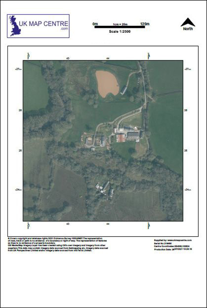
Ordnance Survey Aerial Imagery 1:2500 Scale Extracts - OrthoRectified (no building lean)
Ordnance Survey Aerial Imagery 1:2500 Scale Extracts are high-resolution OS aerial maps created from licensed aerial photography.
These extracts are designed for professional use in planning, surveying, and analysis. They form part of the OS MasterMap Imagery Layer, providing users with true orthorectified imagery that removes building lean and delivers a consistent top-down view of the landscape. Delivering an accurate, real-world view, these maps support tasks ranging from site assessments to impact assessments.
Order your Ordnance Survey Aerial Photos online today and get expertly corrected imagery with fast digital delivery direct to your email inbox.
What Is a 1:2500 Scale Aerial Map?
An OS Aerial map at 1:2500 scale is a high-resolution extract of aerial photography supplied as part of the OS MasterMap Imagery Layer.
Each map is aligned to the OS MasterMap Topography Layer and is incredibly detailed, expertly colour-balanced, and corrected for geometric distortions. This makes it accurate for use by planners, surveyors, engineers, and professional analysts.
Key Features and Benefits:
- Delivered as 1:2500 OS maps aligned to the national grid
- Used for planning, land analysis, and environmental monitoring
- From OS aerial photography programme with up-to-date, licensed data
- Available in multiple sizes from A4 to A0 and up to 90cm x 90cm
When Do I Need a 1:2500 OS Aerial Map?
A 1:2500 aerial map is ideal for projects that demand licensed, accurate imagery instead of free or generic satellite maps of the UK. These detailed extracts provide compliant aerial maps, created from aerial photography, trusted by councils, architects, and infrastructure developers.
Typical Uses Include:
- Land Registry submissions needing reliable aerial photography maps
- Estate management and utility projects that require aerial maps of the UK
- Site assessments where a clear aerial view map gives context beyond standard mapping
- Vegetation and infrastructure projects that benefit from current OS aerial photos