


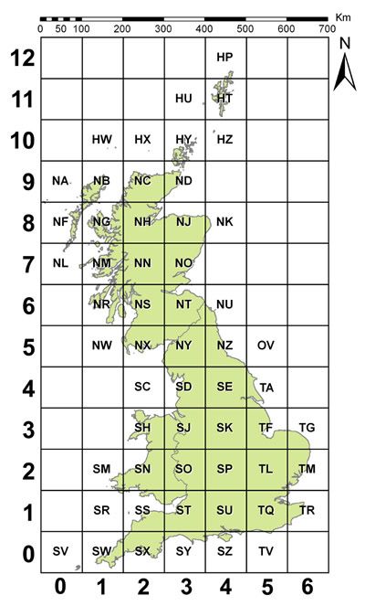
Ordnance Survey National Grid
National Grid references are a compact way of stating the easting and northing coordinates of any point in Great Britain…
The National Grid is used on all Ordnance Survey maps. By giving a National Grid reference, you can pinpoint any location in Great Britain.
The video below explains how the National Grid is devised and how to give the National Grid reference for any location:
4 figure grid references - e.g. 2000,6000
6 figure grid references - e.g. 200000,600000
Summary: How the grid reference system (British National Grid) for Great Britain works:
 |
|
1. What is the Ordnance Survey National Grid?
The National Grid is a coordinate system used on all Ordnance Survey maps of Great Britain. It allows you to pinpoint any location by using grid references (eastings and northings) rather than latitude/longitude.
2. How do grid references work on the National Grid?
Great Britain is divided into 100 km × 100 km grid squares each identified by a two-letter code. Within each square, locations are given via easting (distance east) and northing (distance north) values e.g., “NS 200000,600000”.
3. Why is the National Grid important for mapping and surveying?
Because the National Grid provides a standardised, precise coordinate framework, it underpins accurate mapping, planning, design, CAD workflows, and location referencing across UK infrastructure and mapping products. It ensures consistency in scale and position.
4. Can I convert between the National Grid and latitude/longitude?
Yes - the National Grid system, based on the OSGB36 datum and Transverse Mercator projection, can be converted to WGS 84/longitude-latitude and other coordinate systems using established transformations and tools.
5. How do I specify a location using a National Grid reference?
First identify the two-letter grid square, then add numeric eastings and northings. For example a 4-figure grid reference might look like “SO 84” (eastings 380000, northings 240000). More precise references can use 6 or more digits for better accuracy.
Why Buy from Us?
