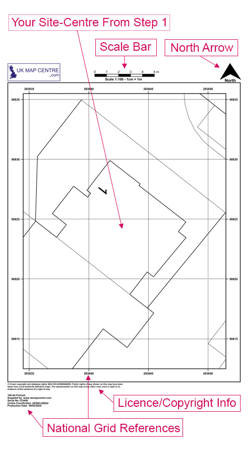
OS 1:100 Scale Block Plan for Dropped Kerb Application Drawings
A 1:100 scale dropped kerb application drawing is a detailed extract from the OS MasterMap® Topography Layer. It is enlarged to clearly show the kerbline, footway, pavement, property frontage and vehicle access points. 1:100 scale maps support dropped kerb planning applications by accurately marking proposed driveways, parking areas or access changes.
This plan meets local council submission standards, including those required for planning permission. It features a scale bar, north arrow, grid references and an official Ordnance Survey licence number.
Order online in minutes. Our 1:100 OS maps are digitally delivered within 30 minutes and are accepted by all UK planning authorities.
WHAT IS A 1:100 SCALE DROPPED KERB PLAN?
An Ordnance Survey 1:100 map is a zoomed-in extract of the OS MasterMap Topography Layer®. It's often referred to as a footway crossing plan, a 1:100 block plan, or a 1:100 dropped kerb drawing. It also functions as a dropped kerb standard drawing, accepted by many local authorities.
It provides the scale and details needed for:
- Driveway or house extension proposals
- Complying with Dropped Kerb Planning Applications
- Illustrating exact access points
- Showing any trees or grass verges used by landscape architects and gardeners
This is not the same as a location plan. It provides greater resolution for kerb alterations or surface changes, and may be used alongside a 1:1250.
WHEN DO I NEED A DROPPED KERB PLAN?
Dropped kerb plans are typically needed when applying to your local council to alter the kerb or footway of your property. It’s often a required document in the application process, especially if:
- The property is located on a classified road
- The site falls within a conservation area or near a listed building
- Written consent is required from neighbouring landowners or the council for trees that may be affected
- You plan to convert a front garden into a driveway or parking area
A site plan 1:100 map illustrates safety, visibility, and layout clearly for planning review.
WHO SHOULD USE THIS 1:100 DROPPED KERB PLAN?
1:100 scale maps are essential for both private and professional use cases.
Common users include:
- Homeowners applying to install a driveway or improve vehicle access
- Architects and planning consultants managing kerb change submissions
- Contractors working on public paving or construction
- Legal professionals handling land boundary form submissions
- Designers or landscapers working on access redesigns
Having difficulty understanding some of the terms used in planning applications? Check out our Understanding Ordnance Survey Map Jargon page.