


OS MasterMap Topography Layer® - GIS Vector Format Maps DXF | SHP | GML - Email delivery in 20 minutes
Available in GIS Format SHP | GML | GPKG | GeoTIFF and DWG | DXF format for CAD
Ordnance Survey Premium Licenced Partner • Fully Licenced official OS mapping • Scalable and Layered OS Vector Data • No sign-up needed – checkout instantly
Download Samples
GeoPackage (GPKG) ↓ GML ↓ SHP - Esri ↓ DWG - Colour ↓ All Layers | DWG ↓ OS Styling GuideOS MasterMap Topography Layer® - GIS Maps (GML / GeoPackage / SHP) & CAD Vector (DWG / DXF)
The OS MasterMap Topography® Layer is a digital mapping dataset representing over 500 million real-world features across Great Britain - roads, buildings, parks and waterways, each uniquely identified and maintained by Ordnance Survey. Built for GIS mapping and CAD-based projects that require precise spatial referencing.
Select map areas as small as 100 m × 100 m (1 hectare) to avoid unnecessary data and reduce cost. A custom rotation tool allows even tighter fitting around irregular project boundaries.
Order GIS maps online with fast delivery, flexible formats, and precision you can trust. UK Map Centre provides licensed OS MasterMap® data tailored to your area.
Always current - OS MasterMap is updated on a six-week cycle, so your base data reflects what's actually on the ground today.
Accepted for planning - OS MasterMap is the approved mapping for UK planning applications and Land Registry submissions. Using it means your site plans start from an authoritative, accepted source.
What Is a GIS Map?
A GIS map is a type of digital map used in a geographic information system (GIS) to link location data with descriptive information. These maps use vector layers to visualise spatial features, enabling users to analyse data, identify patterns and extract actionable insights.
With tools like ArcGIS and QGIS, professionals use GIS mapping in the UK to support spatial analysis, manage assets and plan land use. Ordnance Survey MasterMap data is ideal for detailed geographic information across multiple categories, helping users make better decisions with reliable mapping.
When Do I Need a GIS Map?
GIS maps are used when you need to analyse data linked to location, visualise the geography or explore patterns across a space. They guide decision-making by combining descriptive information with accurate layers of features. These maps are essential for professionals who rely on GIS technology and spatial analysis tools to assess risk, plan infrastructure or manage assets.
Typical Users Include
- Local authorities using GIS tools for planning
- Utility companies managing location data and routes
- Surveyors and engineers producing custom GIS maps
- Environmental teams modelling land use
- GIS consultants presenting data for development or policy
- Architects needing accurate site context
GIS Software Compatibility
- QGIS
- ArcGIS Pro
- ArcMap
- MapInfo
- FME
- Global Mapper
- GeoServer
- PostGIS
- Cadcorp SIS
- … all platforms that read GPKG, GML or SHP
CAD Software Compatibility
- AutoCAD by Autodesk
- Revit
- Civil 3D
- MicroStation
- BricsCAD
- Draftsight
- SolidWorks
- LibreCAD
- Adobe Illustrator
- … all CAD packages that read DWG or DXF
What's in the DWG Colour File?
- Buildings - closed polylines, filled or outline
- Roads, tracks & paths - carriageways, pavements, kerb lines
- Boundaries - land parcels, property boundaries, fences, walls
- Water - rivers, lakes, ponds, drains
- Vegetation - woodland, scrub, gardens, orchards
- Structures - bridges, steps, overhead lines, pylons
- Rail - track, platforms, signals
- Building heights - ground, eave & roof levels
- OS cartographic symbols and text labels
- OS grid frame with BNG coordinates
All Sample Downloads
GeoPackage ↓ GML ↓ GML - MapInfo ↓ SHP - Esri ↓ GeoTiff ↓ DWG - Lines ↓ DXF - Lines ↓ DWG - Colour ↓ Contours | DWG ↓ Contours | DXF ↓ DTM Points | DWG ↓ DTM Points | DXF ↓ All Layers | DWG ↓ All Layers | DXF ↓More Documents
User | Starter Guide Product Overview Doc Technical Info Real World ObjectsStyling for GPKG | GML
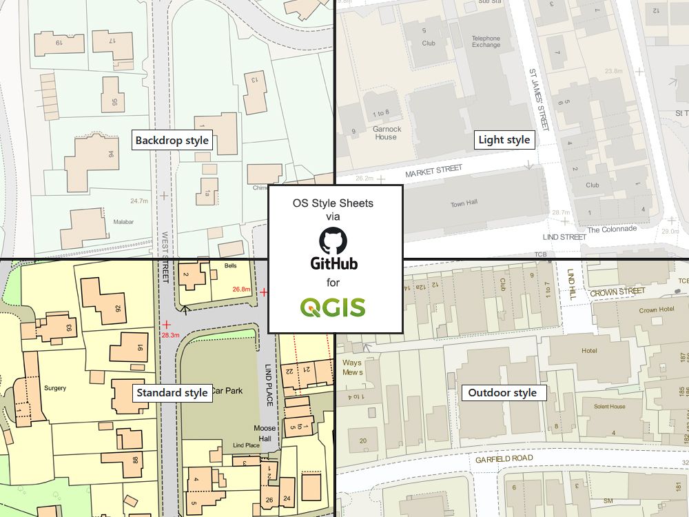
OS GitHub Style Styling Guide Standard Styling Spec.Videos
How to Style | QGISQGIS Supporter:

AGI Member:

Alternative Products:
Extracts: PDF | JPG | TIFF - 1:1250 Extracts: PDF | JPG | TIFF - 1:2500 Aerial: PDF | TIFF | JPG - 1:1250